
Buoy & Marker Messages
"Red Sky at Morning, Sailor take warning! Red sky at night, sailor's delight." Almost anyone who's ever studied weather, or has even hung out around a marina surely knows this old rhyme. It's easy to remember and it offers valuable information. Even if you don't remember it, it'll come back to you during that next red sunset.
Putting the rhyme to other nautical/marine information is a handy way to learn and remember important and practical terms and regulations. Take channel buoys, for example. Those of you who tend to paddle in and out of marinas or ports know there are all sorts of markers and buoys dotting the channels leading in and out of harbor areas. Knowing what each marker means will help you anticipate water traffic and marine obstacles as well as guide you through areas you have never visited before. All these markers are on nautical charts.
There are two systems for marking waterways in the United States, the US Aids to Navigation System (ATONS) and the Uniform State Waterway Marking System. ATONS includes the western river systems. ATONS is the official system that began phasing out the USWMS in 2003. There are also intercoastal waterways that run along the coast of America, literally all the way from New England to down along the coast of Texas. There are specific markers for these lanes as well. With time and practice you should be able to remember what each means.
TAHE 10'6 & 11'6 SUP-YAK Inflatables
2-in-1 Kayak & Paddle Board complete packages for single or tandem use.
The navigational marking system in the U.S. is an interesting and complex array of signs and symbols. Markers that are unlighted are called day beacons. "Lights" are navigational aids lighted at night. A "buoy" is a floating navigational aid.
To get started, let's remember the rhyme that is so common, even landlubbers can recite it by heart:
"Red-Right-Return"
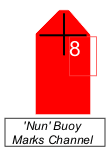
Ok, so it's doesn't rhyme, it should still be an easy way to pique your memory that this refers to red channel buoys. Red channel buoys will be on your right side when you are coming back into the harbor area from the sea or are heading upstream. They are always marked with even numbers - that get increasingly higher as you return from the sea.
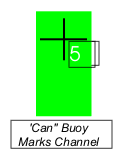
Floating red markers are called "nuns" and have a triangular top. Floating green markers area called "cans" and have a conventional square or flat top. There are also "preferred" channel markers or junction markers. These indicate a preferred/main channel. Channel markers are usually red and green. If the red is on top, it's just like the red nun -keep it on you right. If you want a branch channel, consider the green channel keeping the bottom green marker to your left. The Intercoastal Waterway uses yellow markers to designate its channels: Yellow square should be kept to port; yellow triangles kept to the starboard side.
Here are some of the most common markers, how they are defined and what type of information they convey. I've created the rhymes here, but encourage you to find your own poetic flow to help you remember these as well.
The Nun buoy marks the right side of the returning/upstream channel. There is no rhyme for green buoys since they are the opposite of the well-known red phrase. If you were heading towards the sea, or downstream, the green/can buoy would be on your right. But if you struggle with the differences, maybe this will help you remember:
"Green Can on Right - To Open Seas Tonight
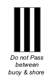
If you see a black/white striped marker, stay on the center channel side of this zebra-marked buoy.
"Vertical Black/ White Stripes galore, don't pass between this buoy and shore!"
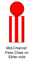
A can buoy with vertical red and white stripes with a red ball on top indicates the center of the channel. You want to pass close to this buoy on either side.
"Vertical Red, Vertical White, marks mid channel, pass left or right."
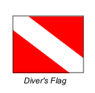
Another popular sign, represented usually by a flag waving from a ring buoy is the Diver's Flag. This is a red rectangle with a broad white diagonal strip running from the upper left to the lower right. It signals a diver below and you are required to stay at least 150 feet away.
"Diagonal White on Red display - Stay 150 feet away!"
If the divers are working off of a ship that is anchored in the area, that ship will fly a white flag with a red forked tail meaning it's a craft with limited movement capabilities.
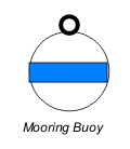
"Belt of blue on a white ball float - marks a place to moor your boat".
This one is good to know to anticipate boating traffic in a small area or near a possible launch site.
"Yellow Marker, boaters read, Information you must heed!"
These are informational buoys usually issuing a warning or announcing important information or rules such as prohibiting boats from entering a milfoil/noxious weed area.
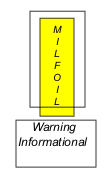
"Orange on White/Above-Below, Information you must know".
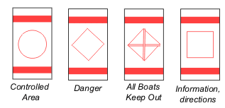
These can buoys with the orange belt around their tops and bottoms provide information of various types.
- The orange circle indicates a controlled area
- The diamond = danger
- Diamond with cross hatches = boats keep out
- Orange square = general information.
There are many combinations of patterns and differing circumstances that require a different navigational marker. Like most skills, these require time and practice to learn. Have fun learning the few that you might run across in your paddling.
Tom Watson, an avid sea kayaker and freelance writer is also the author of "How to Think Like A Survivor" available on Amazon.com and most major bookstores.
Related Articles

Whether it’s passing information along a raging river channel, across a wide expanse of ocean or…

Reactionaries are diagonal breaking waves or holes, and are a common phenomenon on big water rivers.…

I once asked some whitewater experts if they thought 15-16 year old's who had never paddled a canoe…

One of the great things about kayaking is that on a very simple level, you can just slip on a life…